Rivers and Lakes Enabled Early Hominin Dispersals in Iran
A new model of paleoclimate and hydrology in Iran reveals favorable routes for Neanderthals and modern human expansions eastwards into Asia
Although often understudied, the archaeological record of Iran reveals a human presence reaching back to the Stone Age. Past investigations have identified multiple Lower and Upper Palaeolithic sites, including the discovery of Neanderthal fossils in the Zagros Mountains, but much about Iran’s prehistory remains to be understood. Now, a new study led by Mohammed Javad Shoaee of the MPI of Geoanthropology investigates the environmental history of Iran to better understand how climate impacted hominin dispersals and settlements in Iran.

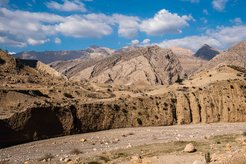
The researchers found that wetter conditions supported human dispersals across Iran during multiple periods of the distant past. During Marine Isotope Stage (MIS) 5, a warm, humid period beginning roughly 130,000 years ago, lakes and rivers enabled two pathways for human groups. One was a northern route through the Alborz and Kopet Dagh Mountains and north of the Dasht-I Kavir desert. The other route, first identified here, ran south along the Zagros Mountains before extending eastwards towards Pakistan and Afghanistan.
The researchers also found evidence for a potential northern route during MIS 3, beginning about 57,000 years ago, which, given artifacts attributed to multiple tool making groups, could have permitted interactions between modern humans and Neanderthals.


These finds highlight the importance of Iran for our species’ dispersals out of Africa and around the globe. As in other regions long considered too arid for early human occupations, such as Arabian Peninsula, recent palaeoclimatic research is changing how we understand the human story and the role that changing climates have played.
To find out how human groups made their way into Iran, the team developed the first spatially comprehensive, high resolution palaeohydrological model for Iran. They then compared their model, which showed when and where water was available, to the distribution of previously documented archaeological sites. The result was a clear relationship between the availability of water and the evidence of human presence.
Not only does the current study help to explain the presence of previously documented sites, it also serves as a guide for future archaeological surveys in the region.
“Our paleohydrological analyses identified 145,354 km of rivers and 115 paleolakes calculated from 6380 paleolake deposits. Only a handful of these paleolakes have so far been studied,” says Shoaee.
By focusing on regions where water once made human occupations possible, researchers can maximize the potential of finding archaeological features in future research.