Digital Archaeology Research Group
Digital archaeology is the integration of digital tools and techniques with traditional archaeological methods of investigation, recording, and interpretation. It also examines the ways in which digitalisation augments archaeology’s capabilities and alters its perspectives. The Digital Archaeology Research Group at the Max Planck Institute for Geoanthropology approaches the landscapes and lives of the past through digital methodologies for data collection and analysis in order to understand processes of change both within antiquity and between the distant past and today. With a focus on remote sensing and ground scanning technologies, group members develop innovative techniques for documenting the remains of past societies and their disposition in the present.

By applying methods of remote sensing documentation such as image interpretation, GIS, and Machine Learning (ML)/Deep Learning (DL) to high-resolution satellite imagery, group members establish a baseline of geospatial data. They then use these data to identify ancient site distribution patterns as well as present-day threats and disturbances to those sites. Analysts deploy Very-High-Resolution (VHR) drone mapping, Light Detection and Ranging (LiDAR), and Structure-from-Motion (SfM) techniques to produce complementary datasets in the field. Database development underpins the core function of the Digital Archaeology Group, using semantic modelling, digital plurality, and Linked Open Data (LOD) methods to integrate and preserve datasets, interpretations, and paradata. Ultimately, Digital Archaeology at the Max Planck Institute strives to ensure that the digital data created in the present is a fair, meaningful, and ethically produced representation of our non-digital past.
Projects
Mongolian Archaeology Project: Surveying the Steppes (MAPSS)
Project members: Prof. Nicole Boivin (PI); Prof. Michael Petraglia (Co-I), Dr. Michael Fisher, Dr. Bayarsaikhan Jamsranjav, Amina Jambajantsan, Dovydas Jurkenas


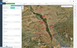
MAPSS is a digital documentation project supported by Arcadia, a charitable fund of Lisbet Rausing and Peter Baldwin, that records the rich archaeological and cultural heritage landscapes of Mongolia. MAPSS integrates manual remote sensing and computer vision with the digitalisation of archival records and ground truthing surveys to identify the locations, attributes, and conditions of archaeological sites and features across Mongolia. Partnering with the Mongolian Institute of Archaeology and the National Centre for Cultural Heritage, MAPSS complements the strong tradition of Mongolian archaeological research and heritage documentation by developing a country-spanning geospatial database using the Arches open-source software platform.
Visit https://mapss.shh.mpg.de/info/ to learn more.
Tell Surezha Excavation Project
Project members: Dr. Michael Fisher (in collaboration with PI Prof. Gil Stein, University of Chicago)


Since 2012, the Oriental Institute of the University of Chicago has been using multidisciplinary methods to explore the Upper Mesopotamian site of Tell Surezha, located on the Erbil Plain in the Kurdish Autonomous Region of Iraq. Directed by Prof. Gil Stein (U. Chicago) and co-directed by Dr. Michael Fisher (MPI-GEA), the project focuses on the Chalcolithic occupation of the high mound, which spans the 6th-4th millennia BCE. Fieldwork activities employ 3D mapping, controlled surface collections, and stratigraphic excavations, while instrumental neutron activation analysis (INAA), and archaeobotanical and zooarchaeological analyses are performed in the laboratory. The goal of the project is to improve understanding of emergent social complexity in Chalcolithic northern Mesopotamia and corresponding processes of urbanisation. INAA has demonstrated early patterns of trans-regional exchange, as well as local emulation practices, while study of the flora and fauna suggest shifts in economic strategies toward specialisation and commensal consumption activity in the 5th millennium BC.
Northern Realm Project (NRP)
Project members: Dr. Bayarsaikhan Jamsranjav (in collaboration with Profs. Alicia and Brian Miller, University of Michigan, and Dr. Julia Clark, NOMAD Science NGO)
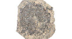
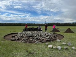
The Northern Realm Project explores the archaeological landscape of Khovskol aimag in northern Mongolia through field surveys and excavation in order to both understand the funerary history of the region and protect the many substantial burials endangered by looting and natural elements. The project has discovered numerous disturbed graves and has uncovered some of the country’s most spectacular Mongol-period finds, including well-preserved silk tapestries and intricately carved bone objects. NRP also offers hands-on training for student conservators and archeologists in conservation, survey, excavation, and digital recording methods.